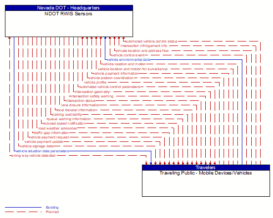
Interface: NDOT RWIS Sensors - Traveling Public - Mobile Devices/Vehicles
Architecture Flow Definitions
automated vehicle control parameters (Planned) Applicable ITS Standards
Information, instructions, and control parameters for automated vehicle operations including current system conditions and advisories, control parameters (e.g., speed, required vehicle performance profiles, gaps or headways) and check in/checkout instructions.
automated vehicle control status (Planned) Applicable ITS Standards
Data provided by a connected vehicle identifying it's current mode and operational status and information provided to support checkin/checkout of the lane and coordinated maneuvers while on the automated facility.
intersection geometry (Planned) Applicable ITS Standards
The physical geometry of an intersection covering the location and width of each approaching lane, egress lane, and valid paths between approaches and egresses. This flow also defines the location of stop lines, cross walks, specific traffic law restrictions for the intersection (e.g., turning movement restrictions), and other elements that support calculation of a safe and legal vehicle path through the intersection.
intersection infringement info (Planned) Applicable ITS Standards
Vehicle path information sent by a vehicle that is violating the stop bar at an intersection. This flow includes the vehicle's position, heading, speed, acceleration, transmission, steering–wheel angle, braking status, size information and trajectory.
intersection safety warning (Planned) Applicable ITS Standards
A warning of an imminent unsafe vehicle infringement at an intersection that may endanger other vehicles or pedestrians. This allows vehicles approaching the intersection to be warned in the event of an imminent red light or stop sign violation or potential infringement on an occupied crosswalk. All connected vehicles at the intersection receive the warning, including both the infringing vehicle and other vehicles at or near the intersection.
intersection status (Planned) Applicable ITS Standards
Current signal phase and timing information for all lanes at a signalized intersection. This flow identifies active lanes and lanes that are being stopped and specifies the length of time that the current state will persist for each lane. It also identifies signal priority and preemption status and pedestrian crossing status information where applicable.
lane closure information (Planned) Applicable ITS Standards
Lane closure information provided to passing vehicles. This flow provides information about roadway configuration changes such as lane closures and shifts.
local traveler information (Planned) Applicable ITS Standards
Traveler information including traffic, road, and weather conditions for a particular locality. This flow includes the location–specific traveler information and time effectivity of the information.
parking availability (Planned) Applicable ITS Standards
Information on available parking. This flow identifies available spaces with associated information about parking restrictions and location for each available space.
private location and address flow (Planned) Applicable ITS Standards
Any information flow between Vehicle/PID and Center or CCMS that the initiator needs to be kept private. Privacy in this sense means that the receiver does not receive the network address of the initiator, nor does it receive the geographic location of the initiator. Flows that depend on initiator geographic location cannot use this service.
queue warning information (Planned) Applicable ITS Standards
Information regarding formed or impending queues (location of the end of queue, estimated duration of the queue, and other descriptions of the queue condition) and recommendations for upstream vehicles including speed reduction, lane change, or diversion recommendations.
reduced speed notification (Planned) Applicable ITS Standards
Reduced speed zone information provided to passing vehicles. This flow provides the reduced speed limit, the location and extent of the reduced speed zone, and associated warning information.
road weather advisories (Planned) Applicable ITS Standards
Segment–specific weather and road conditions including real–time advisories of deteriorating road and weather conditions, medium–term advisories for the next 2�12 hours, and long–term advisories more than 12 hours into the future. The advisories may include advisories that are issued by the RSE based on locally collected environmental data (e.g., an ice on bridge advisory).
traffic gap information (Planned) Applicable ITS Standards
Measured gap to the next approaching vehicle per lane and direction of travel
vehicle control event (Planned) Applicable ITS Standards
Notification that the vehicle has performed an emergency action that could impact the safety of surrounding vehicles. This includes hard braking and activation of traction/stability control systems or other actions that warrant immediate notification of surrounding vehicles. The information flow conveys the vehicle's position, heading, speed, acceleration, transmission, steering wheel angle, braking status, size information, and trajectory.
vehicle environmental data (Existing) Applicable ITS Standards
Data from vehicle safety and convenience systems that can be used to estimate environmental and infrastructure conditions, including measured air temperature, exterior light status, wiper status, sun sensor status, rain sensor status, traction control status, anti–lock brake status, vertical acceleration and other collected vehicle system status and sensor information. The collected data is reported along with the location, heading, and time that the data was collected. Both current data and snapshots of recent events (e.g., traction control or anti–lock brake system activations) may be reported.
vehicle location and motion (Planned) Applicable ITS Standards
Data describing the vehicle's position, heading, speed, acceleration, transmission, steering wheel angle, braking status, size information, and trajectory.
vehicle location and motion for surveillance (Planned) Applicable ITS Standards
Data describing the vehicle's position, heading, speed, acceleration, transmission, steering wheel angle, braking status, size information, and trajectory. This flow represents monitoring of basic safety data ('vehicle location and motion') broadcast by passing connected vehicles for use in vehicle detection and traffic monitoring applications.
vehicle payment information (Planned) Applicable ITS Standards
Information provided for payment of tolls, parking, and other transportation fees including identification that can be used to identify the payment account or source and related vehicle and service information that are used to determine the type and price of service requested. The information exchange normally supports an account debit to pay fees, but an account credit may be initiated where pricing strategies include incentives.
vehicle payment request (Planned) Applicable ITS Standards
Request for information supporting payments. For fee structures that include incentives, the request may support either an account debit or an account credit or reimbursement.
vehicle payment update (Planned) Applicable ITS Standards
Data written to vehicle equipment to support electronic toll collection or parking payment.
vehicle platoon coordination (Planned) Applicable ITS Standards
Coordination of control commands between leader and follower vehicles allowing vehicles to join, coordinate with, and separate from platoons of cooperative vehicles. This flow shares platoon size, location, and performance parameters (e.g., platoon speed and spacing) between platooned vehicles. It also coordinates maneuvers between platooned vehicles, including maneuvers as vehicles join and leave the platoon.
vehicle profile (Planned) Applicable ITS Standards
Information about a vehicle such as vehicle make and model, fuel type, engine type, size and weight, vehicle performance and level of control automation, average emissions, average fuel consumption, passenger occupancy, or other data that can be used to classify vehicle eligibility for access to specific lanes, road segments, or regions or participation in cooperative vehicle control applications.
vehicle signage data (Planned) Applicable ITS Standards
In–vehicle signing data that augments regulatory, warning, and informational road signs and signals. The information provided would include static sign information (e.g., stop, curve warning, guide signs, service signs, and directional signs) and dynamic information (e.g., current signal states, grade crossing information, local traffic and road conditions, detours, advisories, and warnings).
vehicle situation data parameters (Existing) Applicable ITS Standards
A request for vehicle situation data that includes parameters used to control the data that is reported and the flow of data reported by the vehicle. This flow identifies the type of data/snapshots that are requested and reporting parameters such as snapshot frequency, filtering criteria (data thresholds for reporting), and reporting interval.
wrong way vehicle detected (Planned) Applicable ITS Standards
Notification that a vehicle has been detected traveling in the wrong direction. This can be a direct report by an equipped vehicle that is being driven in the wrong direction or a report of a non–equipped vehicle that has been detected traveling in the wrong direction. It includes the current location, speed, acceleration, and heading of the wrong way vehicle.