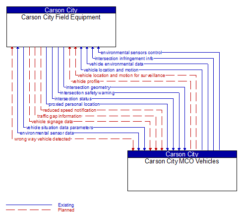
Interface: Carson City Field Equipment - Carson City MCO Vehicles
Architecture Flow Definitions
environmental sensor data (Existing) Applicable ITS Standards
Current road conditions (e.g., surface temperature, subsurface temperature, moisture, icing, treatment status) and surface weather conditions (e.g., air temperature, wind speed, precipitation, visibility) as measured and reported by fixed and/or mobile environmental sensors. Operational status of the sensors is also included.
environmental sensors control (Existing) Applicable ITS Standards
Data used to configure and control environmental sensors.
intersection geometry (Existing) Applicable ITS Standards
The physical geometry of an intersection covering the location and width of each approaching lane, egress lane, and valid paths between approaches and egresses. This flow also defines the location of stop lines, cross walks, specific traffic law restrictions for the intersection (e.g., turning movement restrictions), and other elements that support calculation of a safe and legal vehicle path through the intersection.
intersection infringement info (Existing) Applicable ITS Standards
Vehicle path information sent by a vehicle that is violating the stop bar at an intersection. This flow includes the vehicle's position, heading, speed, acceleration, transmission, steering–wheel angle, braking status, size information and trajectory.
intersection safety warning (Existing) Applicable ITS Standards
A warning of an imminent unsafe vehicle infringement at an intersection that may endanger other vehicles or pedestrians. This allows vehicles approaching the intersection to be warned in the event of an imminent red light or stop sign violation or potential infringement on an occupied crosswalk. All connected vehicles at the intersection receive the warning, including both the infringing vehicle and other vehicles at or near the intersection.
intersection status (Existing) Applicable ITS Standards
Current signal phase and timing information for all lanes at a signalized intersection. This flow identifies active lanes and lanes that are being stopped and specifies the length of time that the current state will persist for each lane. It also identifies signal priority and preemption status and pedestrian crossing status information where applicable.
proxied personal location (Existing) Applicable ITS Standards
Relay of pedestrian, bicyclist, and other non–motorized user locations at an intersection. This relay or rebroadcast of personal locations supports coordination between motorized and non–motorized users that do not have interoperable communications capability.
reduced speed notification (Planned) Applicable ITS Standards
Reduced speed zone information provided to passing vehicles. This flow provides the reduced speed limit, the location and extent of the reduced speed zone, and associated warning information.
traffic gap information (Planned) Applicable ITS Standards
Measured gap to the next approaching vehicle per lane and direction of travel
vehicle environmental data (Existing) Applicable ITS Standards
Data from vehicle safety and convenience systems that can be used to estimate environmental and infrastructure conditions, including measured air temperature, exterior light status, wiper status, sun sensor status, rain sensor status, traction control status, anti–lock brake status, vertical acceleration and other collected vehicle system status and sensor information. The collected data is reported along with the location, heading, and time that the data was collected. Both current data and snapshots of recent events (e.g., traction control or anti–lock brake system activations) may be reported.
vehicle location and motion (Existing) Applicable ITS Standards
Data describing the vehicle's position, heading, speed, acceleration, transmission, steering wheel angle, braking status, size information, and trajectory.
vehicle location and motion for surveillance (Planned) Applicable ITS Standards
Data describing the vehicle's position, heading, speed, acceleration, transmission, steering wheel angle, braking status, size information, and trajectory. This flow represents monitoring of basic safety data ('vehicle location and motion') broadcast by passing connected vehicles for use in vehicle detection and traffic monitoring applications.
vehicle profile (Planned) Applicable ITS Standards
Information about a vehicle such as vehicle make and model, fuel type, engine type, size and weight, vehicle performance and level of control automation, average emissions, average fuel consumption, passenger occupancy, or other data that can be used to classify vehicle eligibility for access to specific lanes, road segments, or regions or participation in cooperative vehicle control applications.
vehicle signage data (Planned) Applicable ITS Standards
In–vehicle signing data that augments regulatory, warning, and informational road signs and signals. The information provided would include static sign information (e.g., stop, curve warning, guide signs, service signs, and directional signs) and dynamic information (e.g., current signal states, grade crossing information, local traffic and road conditions, detours, advisories, and warnings).
vehicle situation data parameters (Existing) Applicable ITS Standards
A request for vehicle situation data that includes parameters used to control the data that is reported and the flow of data reported by the vehicle. This flow identifies the type of data/snapshots that are requested and reporting parameters such as snapshot frequency, filtering criteria (data thresholds for reporting), and reporting interval.
wrong way vehicle detected (Planned) Applicable ITS Standards
Notification that a vehicle has been detected traveling in the wrong direction. This can be a direct report by an equipped vehicle that is being driven in the wrong direction or a report of a non–equipped vehicle that has been detected traveling in the wrong direction. It includes the current location, speed, acceleration, and heading of the wrong way vehicle.